July 11 – Spragge to Sheguiandah
Bike log: 135.0km, 699m of vertical, average speed 27.5km/h
Today’s ride was indeed a bit shorter than yesterday’s, but as usual I “misunderestimated” (to quote President Bush) the difficulty. Largely this was due to the heat and humidity. Wow, was it hot today! It was 34 degrees in the campground when we showed up at 5PM, and it had already noticably cooled down a little bit from earlier in the afternoon. I think it was probably the hottest weather we’ve had so far on the whole trip. Fortunately, we were able to swim in a little river about midway through the day.
The first half of the ride, completing our trip along the North Shore, was pretty uneventful – fairly straight, flat, and just a few small towns. For the second half, we headed south along highway 6 towards Manitoulin Island. The road got interesting there, lots of ups and downs, as well as really terrible pavement for a lot of it! Not much traffic, which was good because there was no shoulder, and the road was pretty badly broken up in many places. Painful to ride on! You know those little stretches that go "bu-dump...bu-dump...bu-dump" as you drive along? After 100km sitting on a bike seat, it's like getting kicked repeatedly in the pants! The hills also started up a bit too – nothing big, but continuous up and down. And as usual, there was a headwind. I was glad I got so much training battling the wind on the prairies, it was hard enough to concentrate on riding with the intense heat and bad pavement.. Still a pretty enjoyable ride though, lots of great views of Lake Huron from the hilltops, as well as small lakes here and there.
Passed through the town of Espanola today. It was just down the road from Spanish. One of those towns is full of “splitters,” I am sure. It had a fairly massive Domtar plant, as well as a dam on the Spanish river that you could see from the highway.
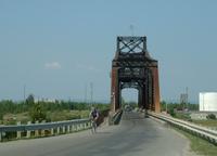 Manitoulin Island is connected by a one lane swing bridge to the north (shown in photo above). It is the largest freshwater island in the world – something like 130km long and 50 km wide. I spent some time here nearly 30 years ago, I have vague memories of many parts of it. I know there is a store in a town nearby where you can get Cream Soda, for instance. It is very nice here, lots of farms and rolling hills. As is common with island life, it seems to be a bit more laid back here as well. Not so much traffic, not so many speeders.
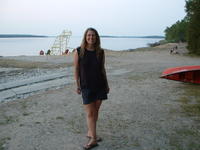
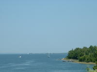 The campsite (Batman’s – we choose it because we liked the name) is also really nice, one of the best kept ones we’ve been in, and the sites are almost as big and separated as a provincial park. They have a beach here as well, which we used immediately upon arrival. The water is pretty warm, much warmer than I expected for this big lake. Still, complete submersion for about 5 minutes did a pretty good job of cooling us down…although we were hot again with a half hour. We are going down the east side of the island, and therefore we are looking out onto Georgian Bay. Tomorrow, we will be catching a ferry (our 3rd of 5 for the trip) off the island and heading down into "southern Ontario." Or is it central Ontario? I am not sure where the official boundaries are. It does not have anything to do with linear distances, as we are already well into the most southern corner, but I feel safe in saying that we will no longer be in Northern Ontario once we get off the ferry!
posted by Chris Jubien @ 3:00 PM
0 comments
![]()

0 Comments:
Post a Comment
<< Home